Clermont’s rolling hills and glittering lakes deserve more than standard photos. If you’re listing a home or land here, aerial images can quickly show elevation, water access, and the lifestyle buyers want. In this guide, you’ll learn which shots make Clermont properties shine, how to stay legal, and what to expect from a smooth drone session. Let’s dive in.
Why Clermont aerials win buyers
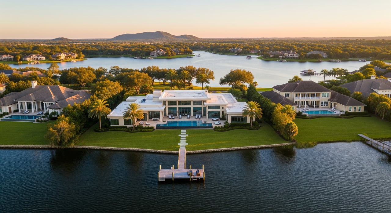
Clermont sits among scenic rises with long sightlines and a network of connected lakes. Aerials help buyers understand waterfront access, usable yard space, roof condition, and privacy in seconds. They also highlight your proximity to the Clermont Chain of Lakes and the energy around Waterfront Park and downtown.
Local highlights to showcase
Waterfront and lake context
If you are on or near the chain, use aerials to show shoreline, docks, and the relationship to neighboring lakes. Buyers respond to clear visuals of boating, paddling, and sunrise or sunset angles over water.
Hills and landmark views
Clermont’s elevation is a standout for Florida. Use aerials to frame long views toward local high points like Sugarloaf and the Citrus Tower to convey scale and panorama.
Trails and downtown access
Short clips can show how close you are to the South Lake Trail, Waterfront Park, and the lakefront pier. Late afternoon at Waterfront Park and downtown Clermont can deliver warm reflections and lively context.
Stay legal and respectful in Clermont
Drone marketing is legal when you follow the rules. Commercial flights must be done by an FAA Part 107 Remote Pilot, which covers preflight duties and operational limits. Review the FAA’s guidance for Part 107 commercial operations.
Florida State Parks, including Lake Louisa State Park, generally prohibit launching or landing without written authorization. Check the park’s policy before planning any shoot on state land using the Florida State Parks FAQ. County and city parks often require permits to launch, even though the airspace is federal. See a summary of Florida and local rules at UAV Coach’s Florida drone laws overview, and contact the City of Clermont Parks & Recreation before flying in public parks.
You also need to be Remote ID compliant and check airspace for authorizations near airports. Learn more about Remote ID and how to request approvals through LAANC.
Respect privacy. Get the property owner’s written consent for launch and close shots, and avoid low flights over occupied neighboring yards. For an overview of Florida privacy considerations, review this guide to state drone laws.
Quick compliance checklist
- Hire a certified FAA Part 107 Remote Pilot and verify insurance.
- Confirm the drone is registered and Remote ID compliant.
- Check airspace and request LAANC if required for your grid.
- Get written permission to launch from private property or a public permit if needed.
- Notify immediate neighbors and keep flights short and respectful.
The shots that sell Clermont homes
Wide oblique reveal (about 150–300 feet)
Use a rising, angled view to show how the property sits within the neighborhood, the rolling terrain, and its relationship to water. Keep the horizon visible to communicate elevation and scale.
Low oblique approach (about 30–75 feet)
This flattering angle highlights the front elevation, driveway, landscaping, and pool. Be mindful of neighboring yards when flying low. For framing and composition tips, see these real estate drone photography pointers.
Top-down parcel view (about 60–120 feet)
A vertical, straight-down shot is ideal for vacant land and larger lots. You can add approximate boundary overlays in post to help buyers visualize the footprint.
Roof and systems pass
Close, careful passes can document roof condition or solar panels. Avoid flying directly over people and keep safety the priority.
Twilight waterfront reflection
Blue hour over the lake can deliver a signature hero image for marketing. Plan for low light and steady conditions.
Best timing and conditions
Golden hour creates warm, inviting light and stunning water reflections, especially along Lake Minneola and the downtown pier. Overcast days work well for even roof lighting. Check local event calendars, since triathlons and festivals may add crowds or restrict access at Waterfront Park and downtown.
What to expect from a drone session
A typical listing benefits from a simple sequence: reveal, approach, detail, and context. Most sellers receive 4 to 8 hero stills plus a 20 to 40 second social clip that shows the home, lot, and nearby amenities. Ask for edited JPGs for the MLS and an MP4 sized for both horizontal and vertical social posts.
Equipment that makes a difference
Drones with larger sensors handle twilight and high-contrast scenes better. Features like a 3-axis gimbal and obstacle avoidance help produce smooth, safe shots in residential settings.
Cost and value expectations
Aerial photography is often an add-on to a standard photo package. In many markets, basic drone photo add-ons run about $100 to $300, while cinematic video packages cost more. For a general pricing overview, review this real estate photography pricing guide. Results vary by property type, but aerials commonly boost engagement because they clarify water access, lot size, and views.
Simple prep checklist for sellers
- Tidy the yard, dock, driveway, and pool areas.
- Move cars, trailers, and bins out of frame.
- Stage boats or paddle gear only if you want them shown.
- Secure pets and notify immediate neighbors of the short flight window.
- Provide written permission to launch from your property and identify a backup spot if needed.
List with confidence
When you list with Sanchez Homes, you get modern marketing that fits Clermont’s unique terrain and lakes. We coordinate certified pilots, handle permissions, and focus on the shots that showcase elevation, water access, and lifestyle. Ready to put Clermont’s hills and lakes to work for your sale? Connect with Omar Sanchez.
FAQs
Are drone photos legal for my Clermont listing?
- Yes. A commercial shoot must be flown by an FAA Part 107 Remote Pilot, the drone must be registered and Remote ID compliant, and launch or landing must be permitted from the chosen site. Review Part 107 rules and Remote ID.
Can I launch from Lake Louisa State Park or a county park?
- Generally no without written authorization. Florida State Parks restrict launching or landing without approval, and many city or county parks require a permit. Read the state park policy and check local rules via UAV Coach’s overview.
Do drone photos help Clermont homes sell?
- Aerials commonly increase buyer engagement by clearly showing waterfront access, lot size, and views, which can drive interest in the first days on market.
How much does drone photography cost near Clermont?
- Pricing varies by scope and vendor. Many markets see $100 to $300 for an aerial add-on, with higher pricing for full video. See this pricing reference.
How do you handle neighbor privacy during a drone shoot?
- We notify immediate neighbors, keep flights short, and avoid low passes over occupied adjacent yards. Florida privacy guidelines are summarized in this state law overview.